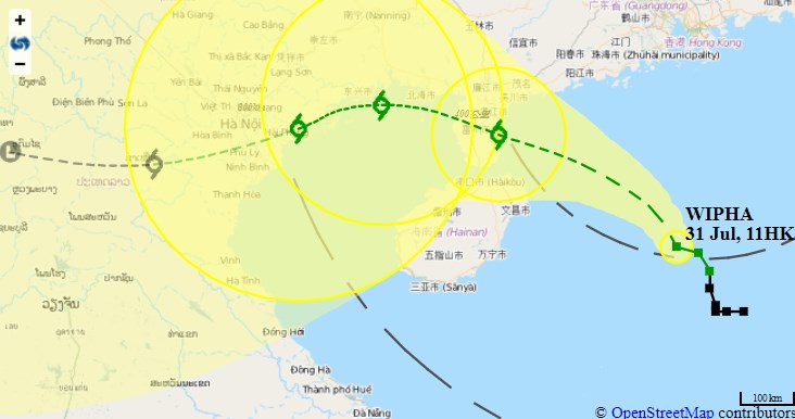
The Observatory raised the T8 storm signal at 1:40pm on Wednesday, as tropical cyclone Wipha approaches Hong Kong.
“According to the present forecast track, Wipha will edge gradually closer to the coast of western Guangdong and will be closest to Hong Kong later today, skirting around 300 kilometres to our southwest. Local winds are expected to strengthen this afternoon,” the Observatory said.
In my first ever typhoon but just feels like a summer day in the UK #HongKong pic.twitter.com/QBdPQdeWKQ
— Graham Little (@londonukm) July 31, 2019
All schools remain suspended.
“In the past hour, the maximum sustained winds recorded at Tate’s Cairn, Waglan Island and Cheung Chau Beach were 69, 67 and 65 kilometres per hour with maximum gusts 93, 94 and 69 kilometres per hour respectively,” the Observatory added.
1340 各行車綫 及 輕鐵 以特別服務運作
受風勢影響,列車於車站間或以較慢的車速行駛
機場快綫則為每 10 分鐘一班
港鐵巴士、機場快綫免費穿梭巴士會於三小時內,隨時因路面狀況影響而停止服務 pic.twitter.com/wHX16CQpDY
— MTR Service Update (@mtrupdate) July 31, 2019
MTR lines suffered delays as commuters were sent home from work.
The Hang Seng index was closed early, finishing down 1.31 percent, or 368.75 points, at 27,777.75.
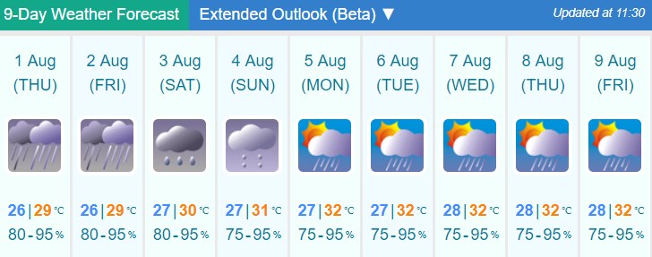
Squally showers and thunderstorms are expected over the coming days.